Showing posts with label Austria. Show all posts

Tuesday, October 25, 2011

Watching the Watchers with Google Maps


Teleschirm is an Austrian website that wants to turn the tables on the pervasive users of CCTV by mapping where video surveillance is being used in public spaces. The site allows anyone to take a photo of a CCTV camera and enter its location on an OpenStreetMap or a Google Map.

Currently Teleschirm has active maps for all the major Austrian towns and cities. As well as the map view it is possible to view a list and photographs of the latest CCTV cameras to be posted to Teleschirm.

_________________

Monday, October 24, 2011

All of Austria on Google Maps


AustroZoom.at wants to be your one stop map for Austria. The application uses Google Maps to provide access to over 522,000 Austrian business locations, localised weather information, route planning and much more.

It is possible to find business locations (such as local restaurants) by using the categorised links beneath the map. The slide menu at the side of the map provides links to the many other functions provided by this Google Map.

These functions include: traffic conditions and webcams, route planning, locally posted messages on Twitter, photographs & videos and local points of interest.

One very nice touch is the way the map has shaded out the rest of the world so that the focus of the map is centred entirely on Austria.

_________________

Monday, September 5, 2011

Proximity Search with Google Maps


Arrlee is a new Google Maps based application that can tell you how far you can travel from a destination on public transport within a certain time.


Arrlee give three good examples of when you might need to carry out a proximity search:

  • You are planning a weekend trip and are looking for locations you can travel to in a specified time
  • You are looking for a new job within a certain commuting time from your home
  • You want to find somewhere to live within a certain commuting time from a specific location

To use Arrlee just enter a station name and set the time available to travel. You can even add points of interest to the map, so, for example, you can find out where all the museums are within a certain travelling time of a location.


Arelee currently works in Germany, Austria and Switzerland but there are plans to add more countries soon. A mobile version is also in development.


______________

Wednesday, January 5, 2011

Google Maps Lottery

Million Mole

Hers's how to win money with Google Maps or lose lots of money trying.

Last year GeoSweep launched in the UK. Geosweep is a Google Maps based lottery game, where players can buy locations on Google Maps. These virtual plots are then entered into two daily cash prize draws.

Million Mole is a similar concept from Italy, however, instead of buying plots you pay to capture one of 1,000 moles hidden on a Google Map. My Italian isn't good enough to work out all the cash prizes available but the current jackpot seems to be just over one thousand Euros.

________________

Sunday, November 14, 2010

Foursquare Check-ins on Google Maps

Stadtkinder
stadt
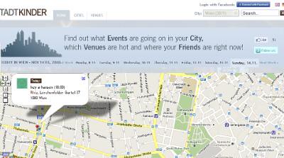
Stadtkinder is an Austrian Google Maps mashup that lets you find events going on in Vienna. The site uses Google Maps to show the locations of 3,877 venues in the city, to tell you what is hot right now and to show you the location of your friends.

The Stadkinder home page features a Google Map that animates through the events occurring in Vienna today. Using the links at the top of the map you can navigate to events happening on different days.

If you select the 'Venues' tab you can see which venues are popular right now based on the number of Foursquare check-ins made at each venue. The popular venues are listed in the map sidebar alongside the number of Foursquare check-ins. The map displays the venues shown and a heat map displays the areas that are hot right now. The map also animates through the locations where people are checking-in with Foursquare right now.

________________

Wednesday, October 27, 2010

Get on Your Bike with Google Maps

Cycling the Alps


Cycling the Alps is a Google Map with a lot of information and some very nice features for anyone who is interested in cycling the Alps.

If you right-click on any of the map markers you can view details about the selected mountain pass, view photogrpahs or videos, view a tour of the pass with the Google Earth browser plug-in, or post a comment.

Using the menu bar at the top of the map you can select to view passes by height, select layers showing webcams, Wikipedia, YouTube or Panoramio photos and you can even view camp-sites.

_______________________