Showing posts with label FourSquare. Show all posts

Thursday, April 12, 2012

Remapping Cities with Google Maps


Livehoods is an interesting project to remap city neighborhoods by ignoring the traditional geographical boundaries and instead looking at human social interactions.

By analysing over 18 million Foursquare check-ins Livehoods, a project from the School of Computer Science at Carnegie Mellon University, has produced three city maps with new neighborhoods based on the patterns of the groups of people that check-in to Foursquare venues.

So far there are three Livehoods maps: New York City, San Francisco, Pittsburgh. The dots on the maps represent different check-in locations. Groups of nearby dots of the same color form a Livehood. The groups are determined when the same people check-in to two nearby locations.

Thursday, March 29, 2012

Create Your Own Fousquare Heat Maps


In the Heat is a heat map creation tool for foursquare check-ins.

Using the application it is possible to create an animated heat map for foursquare check-ins at any location in the world. Creating a heat map is very simple it just require choosing a location and a venue category. It is possible to select from a number of venue categories, for example coffee, stations, nightlife.

In the Heat then creates a Google Map of your location. The map can be animated to view the number of check-ins through time at the venues shown in your map view. The map also comes with a slider control that allows the user to adjust the time displayed on the map.

Friday, December 9, 2011

It's Friday Night on Google Maps


If you live in New York, Paris or San Francisco you should have a look at
Voulez-vous check-in avec moi ce soi before heading out tonight.

Voulez-vous ... uses real-time data from foursquare to see who is checked in at different locations in New York, Paris and San Francisco. Check-ins are then aggregated over one week to assess the current coolness of each venue.

The size of each circle on the map indicates the number of people checked in at each spot. Colors indicate where girls (pink) or guys (blue) are a majority.

Monday, October 10, 2011

Foursquare Venues Nearby on Google Maps


4sqoogle is a Google Map that shows the nearest restaurants, bars, clubs and shops using the foursquare API.

The application allows the user to find nearby venues based on a number of categories (food, nightlife, entertainment and shopping). Each venue shown on the map includes the address, the total number of foursquare check-ins, live check-ins and the number of opinions.

Beneath the map you can also find the venue that has the most check-ins, the venue that has the most live check-ins and the venue that has the most comments on foursquare (based on the venues in the current map view).

Via: PrgrammableWeb

_________________

Wednesday, June 29, 2011

World of Fourcraft on Google Maps


Why settle for being the Mayor of Macy's when you can be the King of New York?

World of Fourcraft is a clever new Google Maps based game that turns your foursquare check-ins into a giant game of Risk. If you live in New York you can sign in with your foursquare account and then swear your allegiance to one of the city's boroughs.

After you have chosen a team every time you check-in with foursquare in New York you add one of your armies to that neighborhood. If your team places the most armies in a neighborhood you win that area for your borough.

World of Fourcraft

Via: Mashable

_____________

Friday, June 17, 2011

Visualise Your Foursquare Data

TripsQ

TripsQ is a data visualisation application that aims to help people make full use of the data they’ve generated through Foursquare. It uses all the data you have gathered while travelling, by turning your check-ins at airports into useful travel statistics.

Everyone who uses Foursquare can easily sign in to tripsQ and visualise their trips and travel itineraries. TripsQ also provides users with detailed statistics on the distance they’ve travelled, the amount of CO² they’ve produced during each trip and other information about their travels.

The site uses Google Maps to visualise your travels around the world. The map has been beuatifully styled with the Styled Maps feature to create a map that complements the overall design of the tripsQ website.

There are some other cool features coming soon as well. One planned feature is to show the tips left by your friends in each of the cities you visit. Another planned feature will be to show the distance you have walked during each of your trips.

________________

Monday, May 30, 2011

Foursquare on Google Maps

4sqmap

4sqmap lets you view your foursquare check-ins on a Google Map and access all your other foursquare statistics.

As well as viewing all the locations you have checked-in you can view all the places where you have earned badges and where you have become the mayor. You can also view the latest check-ins made by your foursquare friends.

The map also allows you to search for the currently trending venues, search for recommended place nearby and search for local venues that are currently running foursquare deals or offers.

_________________

Tuesday, May 10, 2011

Find the Nearest Foursquare Deals

Free Around
Free Around is a web application designed to help you find nearby foursquare deals.

The app is designed to be used from your phone and to be used when you are out and about. When you open the app on your phone it will detect your location and then use the foursquare API to display the nearest foursquare check-in deals on a Google Map.

Details of each venue offering deals nearby are displayed beneath the map. The app also displays the distance to each venue from your current location.

Also See

Checkin Mania: Check-in Deals - A Google Maps based app showing local businesses offering deals through foursquare

_____________

Wednesday, April 27, 2011

Find Foursquare Deals on Google Maps

Checkin Mania: Check-in Deals

Check-in Deals lets you find all the local businesses offering deals through Foursquare. All you have to do is type in your location and you can view all your nearby deals on a Google Map.

As well as being displayed on the map all the deals are listed in the map sidebar. You can filter the displayed deals by 'Newbie Special', 'Check-in Special', 'Mayor Special' etc. If you click on the sidebar listing the location of the selected venue is displayed on the map.

________________

Wednesday, March 9, 2011

Checkin Mania's Google Maps Widget

Checkin Mania

Checkin Mania is a Google Maps mashup to track who is checking in around you using FourSquare, Gowalla, Brightkite and Twitter.

To browse a location you can use the search facility or you can just click on the map. The map will then display all the venues around you and show you who are the top users of that venue with the popular location based social media apps.

It is now possible to add a Chekin Mania map gadget to your own website or to your Google home page. You can adjust the height and width of the Checkin Mania gadget, you can also set a default location and select the services you want displayed (Foursquare, Gowalla, BrightKite or Twitter).

________________

Tuesday, December 7, 2010

Create a Google Map of Your Trip

Mentaway

Mentaway looks like a very simple and effective way to create a travel map without having to do anything more than connect your existing social networking accounts. Currently in an invitation only beta, Mentaway is a new way to create a personal travel map through your postings to Foursquare, Twitter and Flickr.

Using Mentaway you can create a Google Map for a trip and then, using a smartphone, all your check-ins, Tweets and photographs will automatically be added to the map. You can then share your created map with your friends and family and they can check your progress from your personal map.

The map displays all your photos, Tweets and check-ins and includes forward and back buttons to allow users to progress chronologically through your entries. Mentaway is also working on adding Gowalla, Facebook and Tumblr support.

________________

Monday, November 29, 2010

Foursquare Location Updates on Google Maps

Fourtrace

Fourtrace is a research project from the University of California, Santa Barbara. The application uses location updates that users from Foursquare have made publicly available through Twitter, and presents them on a Google Map.

To use Fourtrace you just need to enter a Facesquare user name and then the user's location history will be presented on a map. If the user name is rejected then the person you searched for probably hasn't connected their Foursquare account with Twitter.

If the Foursquare account is connected to Twitter you can then visualise all the location check-ins made on Foursquare. If you click on the map markers you can also read the Tweet made from that location.

________________

Sunday, November 14, 2010

Foursquare Check-ins on Google Maps

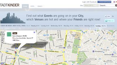
Stadtkinder
stadt
Stadtkinder is an Austrian Google Maps mashup that lets you find events going on in Vienna. The site uses Google Maps to show the locations of 3,877 venues in the city, to tell you what is hot right now and to show you the location of your friends.

The Stadkinder home page features a Google Map that animates through the events occurring in Vienna today. Using the links at the top of the map you can navigate to events happening on different days.

If you select the 'Venues' tab you can see which venues are popular right now based on the number of Foursquare check-ins made at each venue. The popular venues are listed in the map sidebar alongside the number of Foursquare check-ins. The map displays the venues shown and a heat map displays the areas that are hot right now. The map also animates through the locations where people are checking-in with Foursquare right now.

________________

Thursday, October 28, 2010

See How Cities Connect on Google Maps

Autobiopic CityLinks

Autobiopic is a Google Maps based tool to visualise your Foursquare check-ins. The application allows you to animate your recent check-ins on Foursquare and return the distance you have travelled.

Autobiopic has now developed a very cool visualisation tool called Autobiopic CityLinks. This new visualisation tool uses Google Maps to measure the connectivity between cities based on the number of visitors to Autobiopic who have checked into both of those cities.

If you enter a city into the search box you can view a map showing you the connectivity of Autobiopic users. The map shows where people from the city travel by drawing a line from a check-in made in the searched city to other cities that the Foursquare user has travelled to.

There are already 1,500 cities in the CityLinks database so you should be able to view a CityLinks visualisation for most of the major cities around the world.

_____________

Tuesday, October 26, 2010

TweetDeck with Google Maps

TweetDeck for Android

TweetDeck the independent desktop client for Twitter is now available as an Android application with some pretty useful integration with Google Maps.

The TweetDeck application for Android, as you might imagine, allows you to send and read messages from Twitter directly from your smartphone. In addition the application is also integrated with Facebook, Foursquare and Google Buzz.

One of the niftiest features of the application is the deep location integration with checkins and venue details on Google Maps. The applications uses Google Maps to show you the tweets and check-ins around your current location. This allows the user to find nearby venues from Foursquare and read Foursquare tips about that venue.

TweetDeck also allows you to view the recent nearby check-ins of your Foursquare friends. Last week Max Howell, the developer of TweetDeck's Android application spoke at the London GeoMob.

Max spoke enthusiastically about the location features of the application, claiming that he now very rarely organises his social engagements. He now uses TweetDeck instead to find the venues his friends are currently frequenting to facilitate serendipitous social engagements.

_____________

Friday, October 1, 2010

Google Map of Foursquare Check-ins

Real Time Check-ins Map

This Google Map displays in real-time the locations of Foursquare check-ins shared via Twitter.

The map displays the locations of the latest check-ins made to Foursquare. If nothing else the map is interesting in that it gives a rough guide of Foursquare's penetration around the world. At the moment Foursquare appears most popular in North America, Europe, South East Asia and Japan. However Foursquare seems to have made little penetration in South Africa.

Another potential use of the map could be to zoom in on your current location and check-out who is logging in on Foursquare around you.

_____________

Tuesday, August 24, 2010

Hunch - A Local Recommendation Engine

Hunch - Local Search

Hunch is a personal recommendations website. Answer 10 questions and Hunch believes it can offer you great recommendations on thousands of topics. Hunch's recommendations are based on the collective answers of the entire Hunch community. The site claims that every time Hunch is used the hunches get better.

Hunch has now launched Hunch - Local, a Google Maps based suggestion tool to help you find restaurants, stores, museums, hotels and nightlife. After you share your location with Hunch Local you will be shown local recommendations in your vicinity. You can choose which category of recommendations you want to view from a drop down menu.

It is also possible to refine the places shown on the map with a 'popular' slider control. This allows you to view the most popular venues or the most unique (the least popular?). Each suggestion comes with a link to read more about the venue on Yelp, foursquare or on Hunch itself.

Via: Mashable

________________

Wednesday, August 18, 2010

Get Local Tips on Google Maps

Geosay

Geosay is a local information Google Map for finding out what people are saying about different locations on foursquare, Twitter and Wikipedia.

To use the map just enter a location and you can see all the results directly on the Google Map. The results are also listed in the map sidebar, ordered by distance.

It is easy to create a marker for Geosay. Just add the hashtag #geosay to any geolocated tweet and it will be stored in the Geosay database and appear on the map. Geosay has a mobile version of the map. Just go to http://geosay.com in the browser of your mobile phone and you can find local tips wherever you happen to be.

Hat-tip: Street View Funny

_____________

Saturday, August 14, 2010

Animate your Foursquare Check-ins

Autobiopic

Autobiopic is another Google Maps based tool to visualise your foursquare check-ins. The application animates through your recent check-ins on foursquare and returns the distance you have travelled.

To create your own Autobiopic map you just need to sign in with your foursquare account. You can pause the map animation of your check-ins at any time and use a slider control to move to any of your checkins. At each check-in Autobiopic will also display relevant information about the venue, city, date and time. The time of day is also reflected in the Google Maps colour scheme.

Also See
_____________

Wednesday, August 11, 2010

Visualise Your Foursquare Check-ins

Recently a lot of internet sites simultaneously discovered that you can visualise your foursquare check-ins on Google Maps. To see a map of your check-ins all you need to do is right click the KML link on the foursquare feeds page and copy it. Then you can paste the link into the search box in Google Maps and voilĂ  - you have a map of your check-ins.

However this is not the only way to visualise your check-in history. There are actually a few applications that can help you create maps of your check-ins.

Wee Places

Wee Places is probably the best application I've seen for visualising your foursquare check-ins. Wee Places are actually using Cloudmade for the map but the app is so good I had to give it a mention here.

Wee Places provides a map of your check-ins and a time-line. The map animates through your time-line and zaps a yellow line between your check-ins as the time-line plays.

Once the time-line has come to an end you are left with a map of all your check-ins. The size of the map markers reflects the number of times you have checked-in at a venue and, if that is too confusing for you, the marker contains a number telling you the number of check-ins you made here.

4Mapper

Not so visually attractive but effective none-the-less is 4Mapper. Sign into 4mapper with your foursquare account and you can view your check-ins on a Google Map.

4mapper lets you keep your map private or you can make it public and share your map with the world.

4sq Maps
4sq maps is another application that hasn't gone overboard on the design budget but it does have some very nice features.

4sq Maps uses different coloured map markers to show your check-ins, your mayorships and also shows you where your friends have checked-in. 4sq Maps can also provide a static image of your map so that you can place an image of your map in your own website or blog.

Tripline

The wonderful Tripline, that I reviewed last week, also has an option to visualise your foursquare check-ins.

Tripline has some wonderful features that do make it a great way to visualise your check-ins. Unfortunately at the moment you can only import your last fifteen check-ins, so it is limited in scope.

Gowalla Walk

Just in case Gowalla users were beginning to feel left out there is one great Gowalla Google Map mashap. Gowalla Walk is a cool Google Map based application that lets you visualise your Gowalla check-ins.

To create your own Gowalla Walk map all you have to do is enter your username. All the places you have checked-in with Gowalla will then be shown on a Google Map. The locations visited are also listed under the map.

_____________